WEATHER FORECAST
Latest Forecast (Zanesville, OH):
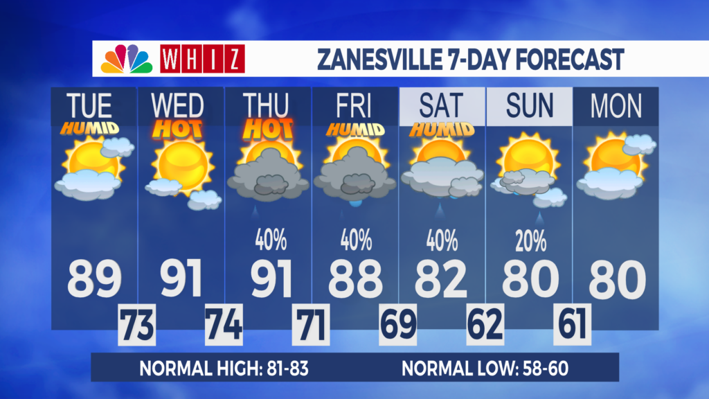
Monday Night: Partly cloudy. Light southwest wind. Low 72
Tuesday: Partly sunny. SW 5-10. High 89
Tuesday Night: Mostly clear. Light southwest wind. Low 73
Hot start to September:
A very warm and quiet start to the new week. Radar and satellite this afternoon show mostly cloudy skies and a couple of light showers in the region. Surface temperatures are around 90, with feels-like temperatures in the low 100s in a few spots.
Tonight will be warm, with lows in the low 70s under partly cloudy skies.
Temperatures will gradually warm through midweek as a heat ridge builds eastward from the Central CONUS. Highs are in the upper 80s tomorrow, then in the low 90s on Wednesday and Thursday, but it will feel like the upper 90s with the humidity. A Heat Advisory will be in effect for Knox, Licking, and Fairfield Counties from Tuesday afternoon through Wednesday evening.
Shower and thunderstorm chances are expected to return this week as storm systems, or “ridge runners,” move around the heat ridge. These ridge runners could bring threats of severe weather and flash flooding. On Tuesday, the Storm Prediction Center has a marginal threat of severe weather for the northeastern half of the viewing area, with damaging wind gusts and large hail as the main threats. The risk is a bit higher on Thursday and Friday, when our area is under a slight risk (level 2/5). Thursday and Friday also currently have our highest chances of showers and thunderstorms this week and feature a marginal risk of flash flooding. Make sure you can receive alerts and monitor the latest forecasts for updates. Overall, forecasting precipitation this week will be tricky, and small changes in the general pattern could significantly change the chance on any day.
Have a great day!
-Chief Meteorologist Keaton Lewis
Contact Me!
Facebook: Meteorologist Keaton Lewis
Instagram: keatonlewiswx
Email: klewis@whiznews.com